


Locus GIS Offline Land Survey
Locus GIS Offline Land Survey ၏ ရွင္းလင္းခ်က္
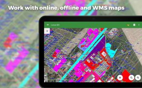
ပရော်ဖက်ရှင်နယ် GIS အပလီကေးရှင်း၊ ၎င်းသည် NTRIP ကလိုင်းယင့်မှပေးသော စင်တီမီတာတိကျမှုရရှိစေရန် ပြင်ပ GNSS ယူနစ်များနှင့် ချိတ်ဆက်မှုအတွက် ဒေတာစုဆောင်းခြင်း၊ ကြည့်ရှုခြင်းနှင့် စစ်ဆေးခြင်းတို့ကို ပံ့ပိုးပေးပါသည်။ ၎င်း၏ အင်္ဂါရပ်များအားလုံးကို အွန်လိုင်း၊ အော့ဖ်လိုင်းနှင့် WMS/WMTS မြေပုံများ အများအပြားရွေးချယ်မှုအထက်တွင် ရရှိနိုင်သည်။
ကွင်းဆင်းလေ့လာမှု
• အော့ဖ်လိုင်းဒေတာစုဆောင်းခြင်းနှင့် အပ်ဒိတ်လုပ်ခြင်း။
• လက်ရှိတည်နေရာ၊ တည်နေရာ ပျမ်းမျှ၊ ပရိုဂရမ်၊ သြဒီနိတ်များနှင့် အခြားနည်းလမ်းများဖြင့် အမှတ်များ သိမ်းဆည်းခြင်း။
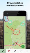
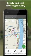
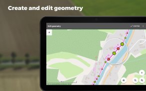
• ရွေ့လျားမှုကို မှတ်တမ်းတင်ခြင်းဖြင့် မျဉ်းကြောင်းများနှင့် အလုံအလောက်များကို ဖန်တီးခြင်း။
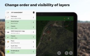
• ရည်ညွှန်းချက်များ၏ ဆက်တင်များ
• ပူးတွဲပါဖိုင်များအဖြစ် ဓာတ်ပုံများ၊ ဗီဒီယို/အသံ သို့မဟုတ် ပုံများ
• အမှတ်များထဲမှ သတ်မှတ်ခြင်း။
• နယ်နိမိတ်သတ်မှတ်ခြင်း။
• အပလီကေးရှင်းသည် နောက်ခံတွင်အလုပ်လုပ်နေသော်လည်း ပစ်မှတ်တစ်ခုပေါ်ရှိ မျဉ်းကြောင်းများမှတ်တမ်းတင်ခြင်း သို့မဟုတ် လမ်းညွှန်မှုအတွက် တည်နေရာဒေတာကို စုဆောင်းခြင်း
သွင်းကုန်/ပို့ကုန်
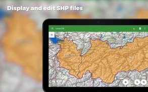
• ESRI SHP ဖိုင်များကို တင်သွင်းခြင်းနှင့် တည်းဖြတ်ခြင်း။
• အချက်အလက်များကို ESRI SHP သို့မဟုတ် CSV ဖိုင်များသို့ တင်ပို့ခြင်း။
• ပရောဂျက်တစ်ခုလုံးကို QGIS သို့ တင်ပို့ခြင်း။
• Third-party cloud storage (Dropbox၊ Google Drive နှင့် OneDrive)
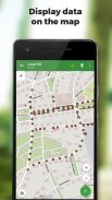
မြေပုံများ
• အွန်လိုင်းအသုံးပြုမှုနှင့် ဒေါင်းလုဒ်အတွက် ကျယ်ပြန့်သောမြေပုံများ
• WMS/WMTS ရင်းမြစ်များ၏ပံ့ပိုးမှု
• MBTiles၊ SQLite၊ MapsForge ဖော်မတ်များနှင့် စိတ်ကြိုက် OpenStreetMap ဒေတာ သို့မဟုတ် မြေပုံအပြင်အဆင်များတွင် အော့ဖ်လိုင်းမြေပုံများကို ပံ့ပိုးမှု
ကိရိယာများနှင့် အင်္ဂါရပ်များ
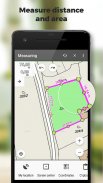
• အကွာအဝေးနှင့် ဧရိယာများကို တိုင်းတာခြင်း။
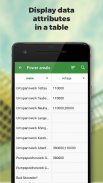
• ရည်ညွှန်းချက်ဇယားရှိ ဒေတာများကို ရှာဖွေခြင်းနှင့် စစ်ထုတ်ခြင်း။
• ပုံစံတည်းဖြတ်ခြင်းနှင့် စာသားအညွှန်းများ
• အခြေအနေအလိုက် ပုံစံပုံစံ - အလွှာအခြေခံ ပေါင်းစပ်စတိုင်လ် သို့မဟုတ် ရည်ညွှန်းချက်တန်ဖိုးအပေါ် မူတည်ပြီး စည်းမျဉ်းအခြေခံပုံစံ စတိုင်လ်
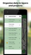
• ဒေတာကို အလွှာများနှင့် ပရောဂျက်များအဖြစ် စုစည်းခြင်း။
• ပရောဂျက်တစ်ခု၊ ၎င်း၏အလွှာများနှင့် ဂုဏ်ရည်များကို လျင်မြန်စွာတည်ဆောက်ရန်အတွက် နမူနာပုံစံများ
• ကမ္ဘာလုံးဆိုင်ရာနှင့် ဒေသတွင်း CRS 4200 ကျော်အတွက် ပံ့ပိုးမှု (ဥပမာ WGS84၊ ETRS89 Web Mercator၊ UTM...)
အဆင့်မြင့် GNSS ပံ့ပိုးမှု
• အလွန်တိကျသောဒေတာစုဆောင်းခြင်းအတွက် ပြင်ပ GNSS လက်ခံကိရိယာများ (Trimble၊ Emlid၊ Stonex၊ ArduSimple၊ South၊ TokNav...) နှင့် Bluetooth နှင့် USB ချိတ်ဆက်မှုကို ပံ့ပိုးပေးသည့် အခြားစက်ပစ္စည်းများ
• Skyplot
• NTRIP ဖောက်သည်နှင့် RTK တည့်မတ်ခြင်း။
• လက်ခံကိရိယာများကို စီမံခန့်ခွဲရန်အတွက် GNSS မန်နေဂျာ၊ တိုင်အမြင့်နှင့် အင်တင်နာအဆင့်စင်တာကို တည်ဆောက်ပါ။
• တိကျမှုထိန်းချုပ်မှု - ခိုင်လုံသောဒေတာစုဆောင်းရန် အနိမ့်ဆုံးသည်းခံမှုစနစ်ထည့်သွင်းခြင်း။
ဖောင်အကွက် အမျိုးအစားများ
• အလိုအလျောက်အမှတ် နံပါတ်တပ်ခြင်း။
• စာသား/နံပါတ်
• ရက်စွဲနှင့်အချိန်
• အမှတ်ခြစ်ရန်နေရာ (ဟုတ်/မဟုတ်)
• ကြိုတင်သတ်မှတ်ထားသောတန်ဖိုးများဖြင့် Ddrop-down ရွေးချယ်မှု
• GNSS ဒေတာ (ဂြိုဟ်တုအရေအတွက်၊ HDOP၊ PDOP၊ VDOP၊ တိကျမှု HRMS၊ VRMS)
• ပူးတွဲပါဖိုင်များ- ဓာတ်ပုံ၊ ဗီဒီယို၊ အသံ၊ ဖိုင်၊ ပုံကြမ်းများ၊ မြေပုံစခရင်ပုံများ
Locus GIS ကို ကျယ်ပြန့်သောစက်မှုလုပ်ငန်းများတွင် အောင်မြင်စွာအသုံးပြုနိုင်သည်-
သစ်တော
• သစ်တောစာရင်း
• သစ်ပင်မြေပုံရေးဆွဲခြင်းနှင့် စစ်ဆေးခြင်း။
• မျိုးစိတ်အုပ်စုများနှင့် အသီးအရွက်များကို ပုံဖော်ခြင်း။
ပတ်ဝန်းကျင်
• အပင်များနှင့် biotopes များကို မြေပုံဆွဲခြင်း၊ မြေပုံထုတ်ခြင်းနှင့် ဧရိယာခွဲခြမ်းစိတ်ဖြာမှုများကို တင်ပြခြင်း။
• Faunal စစ်တမ်းများ၊ ပတ်ဝန်းကျင်ထိခိုက်မှုအကဲဖြတ်မှုများ၊ မျိုးစိတ်များနှင့် နေထိုင်ရာများကို စောင့်ကြည့်ခြင်း။
• တောရိုင်းတိရစ္ဆာန်လေ့လာမှု၊ အပင်လေ့လာမှု၊ ဇီဝမျိုးစုံမျိုးကွဲများကို စောင့်ကြည့်ခြင်း။
စစ်တမ်းကောက်ယူခြင်း။
• နယ်နိမိတ်အမှတ်အသားများကို ရှာဖွေခြင်းနှင့် ကြည့်ရှုခြင်း။
• မြေမျက်နှာသွင်ပြင်စစ်တမ်းများ
• မြေကွက်များကို ကွင်းဆင်းစစ်ဆေးခြင်း။
မြို့ပြစီမံကိန်းနှင့် မြေပုံဆွဲခြင်း။
• ပြည်သူ့လုပ်ငန်းဌာနရှိ လမ်းဒေတာဘေ့စ်များကို အဆင့်မြှင့်တင်ခြင်း။
• ရေပိုက်လိုင်းများနှင့် ရေနုတ်မြောင်းများကို မြေပုံဆွဲခြင်းနှင့် စစ်ဆေးခြင်း။
• မြို့ပြစိမ်းလန်းသောနေရာများနှင့် စာရင်းဇယားများကို ပုံဖော်ခြင်း။
စိုက်ပျိုးရေး
• စိုက်ပျိုးရေးစီမံကိန်းများနှင့် မြေဆီလွှာကို အသွင်အပြင်ဖြစ်စေသော သဘာဝအရင်းအမြစ်များ တူးဖော်ခြင်း။
• စိုက်ပျိုးမြေနယ်နိမိတ်များသတ်မှတ်ခြင်းနှင့် မြေကွက်နံပါတ်များ၊ ခရိုင်များနှင့် ပိုင်ဆိုင်မှုကန့်သတ်ချက်များကို ဖော်ထုတ်ခြင်း။
အခြားအသုံးပြုနည်းများ
• သဘာဝဓာတ်ငွေ့နှင့် စွမ်းအင်ဖြန့်ဖြူးခြင်း။
• လေရဟတ်စိုက်ခင်းများ စီစဉ်ခြင်းနှင့် ဆောက်လုပ်ခြင်း။
• တူးဖော်ရေးကွင်းများနှင့် ရေတွင်းတည်နေရာများကို ရှာဖွေရေး
• လမ်းဖောက်လုပ်ခြင်းနှင့် ပြုပြင်ထိန်းသိမ်းခြင်း။
Locus GIS Offline Land Survey - ဗားရွင္း 1.23.10
(14-02-2025)Locus GIS Offline Land Survey - APK သတင္းအခ်က္အလက္
APK ဗားရွင္း: 1.23.10package: menion.android.locus.gisLocus GIS Offline Land Survey ၏ ေနာက္ဆုံးဗားရွင္း
အျခား ဗားရွင္းမ်ား


က႑တူအက္ပ္မ်ား

သင္ႏွစ္သက္ႏိုင္သည္မ်ားမွာ...


